The Upland Turn: Hand-Painted Pottery Leads Researchers Toward a Surprising New Pathway
On Oak Island, where every layer of soil has the potential to rewrite history, the discovery of a single artifact can alter the direction of an entire investigation. That is exactly what unfolded this week as archaeologists Dr. Aaron Taylor and Miriam Amirault uncovered surprising new evidence near the northeastern edge of the swamp—evidence that may confirm the long-suspected path of the island’s mysterious stone road and its possible connection to the original Money Pit.
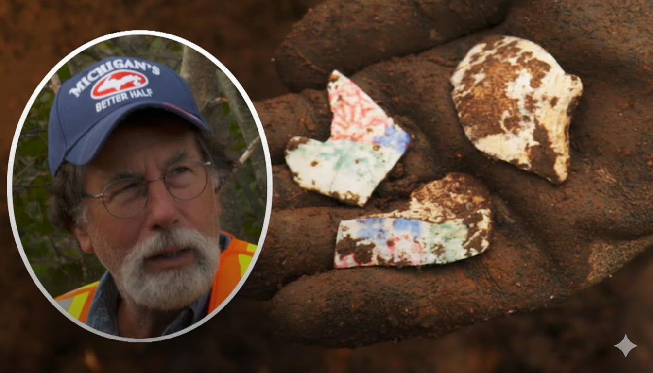
What began as a routine survey in the uplands rapidly evolved into one of the most promising developments of the season. While troweling through fresh test pits carved by heavy-equipment operator Billy Gerhardt, Miriam spotted something unexpected: a vividly hand-painted ceramic fragment displaying rare shades of blue, pink, and green. The colors alone made the discovery remarkable—artifacts with hand-painted decoration are uncommon on Oak Island—but its context made it even more intriguing. It was found directly along the projected line where archaeologists believe the stone pathway may continue.
Dr. Taylor immediately recognized the significance. The fragment’s detailed pattern suggests domestic use, possibly from a teacup, bowl, or refined tableware. But its age remains uncertain. Was it left behind by early settlers after the Money Pit’s discovery in 1795? Or does it point to far earlier activity—evidence that someone may have been transporting goods along this route long before the island’s story became legend?
Rick Lagina arrived moments later to inspect the find, noting that archaeology often reveals meaning through the smallest pieces. A fragment like this, he explained, can become a cornerstone of interpretation once paired with geological evidence, soil analysis, and proximity to man-made features. And there was every reason to suspect that man-made features were nearby.
For weeks, the team has believed the massive stone roadway emerging from the swamp—complete with cribbing timbers, layered stonework, and signs of centuries-old activity—must continue inland. But its exact direction remained elusive. Dr. Taylor’s working theory was that the road veers uphill toward the uplands, rather than continuing straight. The newly found pottery shard, resting just above what appeared to be a disturbed layer, offered enough encouragement to expand the excavation.
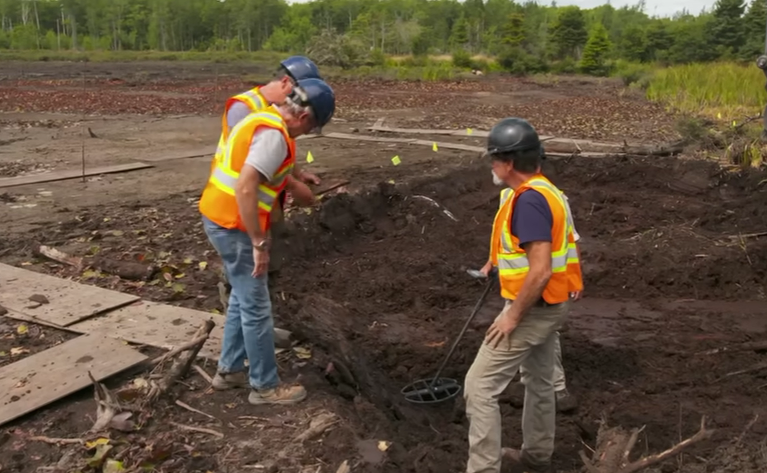
With Rick’s approval, Billy maneuvered the excavator to peel back a shallow slice of earth, exposing a new area for the archaeologists to investigate. What happened next validated the team’s instincts. As Aaron and Miriam knelt to clear soil with shovels and trowels, they immediately exposed a tightly packed layer of cobblestones—stones identical in size and placement to those found along the swamp’s engineered pathway.
“Wow,” Dr. Taylor said as the stones came into view. “I’d say that’s exactly what we’re looking for.”
It was confirmation that the road continues—and turns.
According to Taylor, the alignment suggests the pathway shifts uphill, heading directly inland and possibly toward the area of the original Money Pit. For decades, theorists have speculated that an engineered transport route must have existed to move cargo—whether treasure, tools, or construction materials—from the shoreline toward whatever structure or deposit the builders intended to conceal. Now, for the first time, the archaeological evidence appears to support that idea.
The newly uncovered stones do not continue in a straight line from the swamp. Instead, they appear to redirect the roadway before it disappears beneath centuries of soil. This change in direction is critical. It implies intentional planning by whoever built the road, and it suggests the uplands may have played a larger role in the treasure narrative than previously understood.
The discovery also supports Rick Lagina’s long-held belief that the island’s workings cannot be fully understood without examining how different features connect. A road that transforms from a swamp-side structure into an upland path indicates a coordinated construction effort—one requiring manpower, tools, and a clear objective.
What that objective was remains the ultimate question.
If the road indeed turns toward the Money Pit area, it raises provocative possibilities. Was this route used to transport heavy chests, barrels, or equipment? Was it part of an elaborate concealment strategy, designed to misdirect future searchers by burying clues under natural terrain? Or was it simply a functional pathway used by workers hundreds of years ago, leading from a hidden harbor in the swamp to a central operations point inland?
The team has not yet reached the end of the pathway, but the direction it takes is unmistakable—and compelling.
As excavation continues, the hand-painted pottery shard will undergo further analysis to determine its age and possible origin. Meanwhile, soil samples from beneath and around the stones may offer chemical signatures that reveal human activity, environmental changes, or construction methods.
For now, Rick, Aaron, and Miriam know one thing for certain: the road is leading somewhere significant. Every stone uncovered brings them one step closer to one of Oak Island’s greatest unanswered questions—who built this engineered structure, and where were they going?
With new evidence emerging in the uplands and the pathway pointing toward the island’s most iconic location, the team believes they may be entering a chapter of discovery unlike any in recent years.
The road is rising. The uplands are calling. And the mystery of Oak Island may be standing just ahead, waiting to be unearthed.